GIS is a relatively broad term that can refer to a number of different technologies, processes, and methods. It is attached to many operations and has many applications related to engineering, planning, management, transport/logistics, insurance, telecommunications, and business. For that reason, GIS and location intelligence applications can be the foundation for many location-enabled services that rely on analysis, visualization and dissemination of results for collaborative decision making.
GIS provides a technologically strong platform to every kind of location based business personal to update data geographically without wasting time to visit the field and update in database manually. GIS when integrated with other powerful enterprise solutions like SAP, helps creating powerful decision support system at enterprise level.
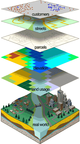
GIS means making intelligent and meaningful maps – maps that can answer the classic three geographic questions: What? Where? Why? More formally, a GIS integrates geospatial data, hardware, software, and geographic concepts to analyze and visualize geographic information. The application of GIS technology is widening beyond its "traditional" scope of geography, planning, and environmental sciences and extends into, for example, public health, social services, homeland security, law enforcement, business and marketing, communications and media, and political science.
GIS is expanding beyond geography, planning, and environmental science and now extends into public health, social services, homeland security, law enforcement, business and marketing, communications and media, political science, and more.
We have all the hardware, software, and field equipment needed for creating routine and advanced mapping and geospatial analysis solutions useful for the following sectors.
- Federal
- State
- Local
- Resilient Communities
- Facilities
- Land Administration
- Public Works
- Architecture Engineering and Construction (AEC)
- Economic Development
- Elections and Redistricting
- Urban and Regional Planning
- Insurance
- Retail
- Manufacturing
- Real Estate
- Banking
- Marketing
- Media
- Electric
- Gas
- Location-Based Services
- Pipeline
- Telecommunications
- Water/Wastewater
- Agriculture
- Climate Change
- Conservation
- Environmental Management
- Forestry
- Mining
- Oceans
- Petroleum
- Water Resources
- Aid and Development
- Defence and Intelligence
- Education
- Health and Human Services
- Mapping and Charting
- Transportation
- Public Safety
- See All Industries
We provide Consultancy Services in Remote Sensing, GIS & Surveying